Cyclone Montha Poised to Make Landfall in Andhra; Flights and Trai
News livelaw.in, LAW, LAWYERS NEAR ME, LAWYERS NEAR BY ME, THE TIMES OF INDIA, HINDUSTAN TIMES, the indian express, LIVE LAW .IN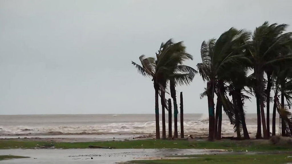
Eastern India braces for the powerful storm: key coastal districts of Andhra Pradesh placed on red alert, more than 50 trains cancelled and flights disrupted ahead of landfall tonight.
Andhra Pradesh |Tuesday, October 28, 2025
The severe tropical storm named Cyclone Montha is now closing in on the eastern coast of India, with a landfall expected between Machilipatnam and Kalingapatnam around the city of Kakinada tonight, October 28, 2025. Meteorologists from the India Meteorological Department (IMD) say the storm has intensified into a “severe cyclonic storm” and is moving north-north westwards, bringing heavy rainfall, strong winds and rough sea conditions.
High alert across coastal Andhra
The Andhra Pradesh government has declared red alerts for multiple coastal districts including Kakinada, East Godavari, Konaseema, West Godavari and Krishna. Officials have directed immediate evacuation of vulnerable low-lying areas and set up relief centres. Chief Minister N. Chandrababu Naidu – in a situation‐room review – ordered the activation of Real-Time Governance centres and deployment of disaster-relief teams including the National Disaster Response Force (NDRF) and the state’s SDRF.
According to the IMD bulletin, the storm is likely to strike with sustained winds of 90–100 km/h, gusting up to 110 km/h, and precipitation of “heavy to very heavy” intensity expected in parts of coastal Andhra on Tuesday and Wednesday.
Disruptions to transport: trains and flights cancelled
With the storm imminent, major disruptions to transport have been announced. The South Central Railway and the East Coast Railway have cancelled more than 50–60 passenger and express trains scheduled to run through the coastal corridor. Key routes such as Vijayawada–Machilipatnam, Rajahmundry–Visakhapatnam and others have been affected.
Flights are also impacted: major domestic carriers have suspended operations to airports at Visakhapatnam, Vijayawada and Rajahmundry as visibility drops and winds intensify. Passengers are being urged to check status and re-schedule.
In addition to rail and air, the Andhra Pradesh State Road Transport Corporation (APSRTC) has suspended bus services in coastal zones and shifted vehicles away from low-lying causeways to higher ground as a precaution.
Storm path and observational data
As of early Tuesday morning, the storm’s centre was located approximately 160 km south-southeast of Machilipatnam and 240 km south-southeast of Kakinada, moving at around 12–15 km/h. Sea conditions off the coast are described as “very rough to high” and expected to turn “extremely high” by landfall.
Authorities have issued danger signals for ports and warned all fishing vessels to stay ashore. The port of Kakinada has already hoisted signal number seven — indicating severe threat to marine operations.
Preparedness and public warnings
State disaster mitigation units have mobilised rescue personnel, medical teams and equipment such as JCBs and power saws in each vulnerable district to handle potential flooding, landslides and wind-damage. The public has been warned against non-essential travel, and residents of coastal hamlets have been moved to safer elevations. In many locations, community-level volunteers, district police and revenue officials are physically evacuating people from shoreline homes.
Schools in affected districts will remain closed as a precautionary measure. District control rooms are functioning round the clock, and uninterrupted communications — including satellite phones — have been ordered in case of network failure
Impact to expect
Meteorologists caution that in addition to high winds, heavy downpours may trigger flash-flooding in river catchments, inundations in low-lying zones, uprooting of trees and damage to standing crops. Coastal erosion and storm-surge risk are also heightened given the strong on-shore winds. Sea-front promenades, jetties and harbour areas may be significantly affected.
Authorities warn that power outages, road closures, rail track flooding and airport disruptions are highly likely. Port operations are suspended and fishermen have been evacuated from vulnerable islands and coastal zones. Communities near the Godavari and Krishna deltas are particularly at risk of water-logging.
Regional ripple effects
While Andhra Pradesh is the primary target zone, neighbouring states are also reinforcing alert systems. Parts of Odisha and northern Tamil Nadu are under orange or yellow alerts, with preparatory evacuations underway. The storm’s outer bands are already lashing coastal Odisha with rain and gusts.
National agencies and meteorological departments are coordinating across states to share data and resources in case the storm tracks farther inland or turns north-west.
What travel and residents should know
- Travellers: Anyone planning flights, trains or buses in the region must check with carriers or service providers. Expect cancellations, delays and diversions.
- Residents: Those in low-lying and coastal zones should heed evacuation orders, move to relief shelters if instructed, secure loose items, avoid waterfronts and shut off electricity if flooding begins.
- Businesses/farmers: Industries along the coast should suspend operations in exposed units and ensure backup power and data protection. Farmers may need to harvest early where possible or shift equipment.
- General public: Avoid travel during the storm period, stay indoors, keep away from fallen power lines and inundated areas, and listen to official alerts.
Outlook & aftermath
The most intense phase of the storm is expected from late Tuesday evening through Wednesday morning. Once landfall occurs, the system may weaken but continue causing rain and gusts inland. The full impact will only be assessed once the system passes and relief operations inspect damage.
Post-storm recovery will involve restoring power, clearing roads, checking railway tracks, reopening airports and assessing agricultural and infrastructural damage. Relief management authorities have already begun mapping high-risk zones and relief logistics.
Source:
